28 February 2009

Credit: NASA/JPL/Space Science Institute
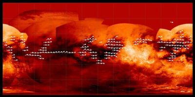
Using data from a radar instrument aboard the Saturn-bound Cassini spacecraft, scientists have produced a map of the global wind pattern on Saturn's moon Titan. The data have been gathered for four years.
In the map, the arrows indicate the direction in which sand is inferred to be transported on Titan’s surface, along dunes observed in radar data. The arrows are superimposed on a base map (see JPL PIA08399) from Cassini's imaging science subsystem. Many of the equatorial dark areas without arrows might have dunes but have not yet been observed with radar. The dune orientations represent only the net effect of winds. It is possible that sand transport only occurs on rare occasions, and winds from different directions can combine to yield the observed dune orientations.
Further Reading
The Cassini-Huygens Mission to Saturn
http://saturn.jpl.nasa.gov/
Titan
http://www.nineplanets.org/titan.html
Aymen Mohamed Ibrahem
Senior Astronomy Specialist